4 Best Sights in Moab and Southeastern Utah, Utah

Monument Valley Navajo Tribal Park

Fodor's choice
Monument Valley Navajo Tribal Park
Guoqiang Xue / Shutterstock

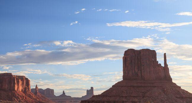
For the most breathtaking (and recognizable) views of the iconic West, this is the place. The soaring red buttes, eroded mesas, deep canyons, and naturally sculpted rock formations found here are an easy 21-mile drive south of Mexican Hat on U.S. 163 across Navajo land. Monument Valley is a small part of the more-than-7-million acre Navajo Reservation and is sacred to the Navajo Nation, or Diné (pronounced din-eh, which means "the people"), as they refer to themselves. For generations, the Navajo have grown crops and herded sheep in Monument Valley, considered to be one of the most scenic and mesmerizing destinations in the Navajo Nation. Director John Ford made this fantasy land of buttes, towering rock formations, and mesas popular when he filmed Stagecoach here in 1938.

The 90,000-acre Monument Valley Navajo Tribal Park lies within Monument Valley. A 17-mile self-guided driving tour on a dirt road (there's only one road, so you can't get lost) passes the memorable Mittens and Totem Pole formations, among others. Drive slowly, and be sure to walk (15 minutes round-trip) from North Window around the end of Cly Butte for the views. Call ahead for road conditions in winter. The Monument Valley visitor center has a small crafts shop and exhibits devoted to ancient and modern Native American history. Most of the independent guided tours here use enclosed vans and you will usually be approached in the parking lot; you can find about a dozen approved Navajo Native American guides in the center. They will escort you to places you are not allowed to visit on your own. This surreal landscape constantly changes with the rising and setting sun.

Buy Tickets Now

Goosenecks State Park

Stare down the spectacular, 1,000-foot cliffs, and you can see how this remote park got its name: the San Juan River's serpentine course resembles the necks of geese. Geologists also say this is the best example of an "entrenched meander" in the world, including rock 300 million years old. The nighttime skies here are legendary, and in 2021 Goosenecks officially became an International Dark Sky Park, a recognition from the International Dark Sky Association. Camping sites are all first-come, first-served. You'll find the park 8 miles northwest of Mexican Hat off Highway 261. 

Moki Dugway

Northwest of the Valley of the Gods, Highway 261 takes you to the Moki Dugway, a graded road that was bulldozed out of a cliff during the uranium boom. It's been improved since it was originally built, but its steep grade and tight switchbacks still provide thrills sufficient for most drivers. From the top of the cliff you're rewarded with outrageous views south over the Navajo Reservation with Monument Valley visible more than 20 miles away. This drive is not recommended for vehicles more than 28 feet in length or weighing more than 10,000 pounds.

Hwy. 261, 9 miles north of Hwy. 163, Mexican Hat, Utah, 84531, USA

Recommended Fodor's Video

Muley Point Overlook

Five miles beyond the Moki Dugway turnoff on Highway 263 brings you to the Muley Point Overlook, which has a panoramic view of the Goosenecks of the San Juan River, the Valley of the Gods, and Monument Valley. It's also 1,000 feet higher in elevation than the Goosenecks overlook farther south.