11 Best Sights in Palm Springs and the Desert Resorts, California

Anza-Borrego Desert State Park

Fodor's choice
Anza-Borrego Desert State Park
sumikophoto / Shutterstock

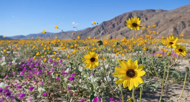
One of the richest living natural-history museums in the nation, this state park is a vast, nearly uninhabited wilderness where you can step through a field of wildflowers, cool off in a palm-shaded oasis, count zillions of stars in the black night sky, and listen to coyotes howl at dusk. The landscape, largely undisturbed by humans, reveals a rich natural history. There's evidence of a vast inland sea in the piles of oyster beds near Split Mountain and of the power of natural forces such as earthquakes and flash floods. In addition, recent scientific work has confirmed that the Borrego Badlands, with more than 6,000 meters of exposed fossil-bearing sediments, is likely the richest such deposit in North America, telling the story of 7 million years of climate change, upheaval, and prehistoric animals. Evidence has been unearthed of saber-toothed cats, flamingos, zebras, and the largest flying bird in the northern hemisphere beneath the now-parched sand. Today the desert's most treasured inhabitants are the herds of elusive and endangered native bighorn sheep, or borrego, for which the park is named. Among the strange desert plants you may observe are the gnarly elephant trees. As these are endangered, rangers don't encourage visitors to seek out the secluded grove at Fish Creek, but there are a few examples at the visitor center garden. After a wet winter you can see a short-lived but stunning display of cacti, succulents, and desert wildflowers in bloom.

The park is unusually accessible to visitors. Admission to the park is free, and few areas are off-limits. There are two developed campgrounds, but you can camp anywhere; just follow the trails and pitch a tent wherever you like. There are more than 500 miles of dirt roads, two huge wilderness areas, and 110 miles of riding and hiking trails. Many sites can be seen from paved roads, but some require driving on dirt roads, for which rangers recommend you use a four-wheel-drive vehicle. When you do leave the pavement, carry the appropriate supplies: a cell phone (which may be unreliable in some areas), a shovel and other tools, flares, blankets, and plenty of water. The canyons are susceptible to flash flooding, so inquire about weather conditions (even on sunny days) before entering.

Borrego resorts, restaurants, and the state park have Wi-Fi, but the service is spotty at best. If you need to talk to someone in the area, it's best to find a phone with a landline.

Stop by the visitor center to get oriented, to pick up a park map, and to learn about weather, road, and wildlife conditions. Designed to keep cool during the desert's blazing-hot summers, the center is built underground, beneath a demonstration desert garden containing examples of most of the native flora and a little pupfish pond. Displays inside the center illustrate the natural history of the area. Picnic tables are scattered throughout, making this a good place to linger and enjoy the view.

The sites and hikes listed below are arranged by region of the park and distance from the visitor center: in the valley and hills surrounding Borrego Springs, near Tamarisk Campground, along Highway S2, south of Scissors Crossing, and south of Ocotillo Wells.

A 1½-mile trail leads to Borrego Palm Canyon, one of the few native palm groves in North America. The canyon, about 1 mile west of the visitor center, holds a grove of more than 1,000 native fan palms, a stream, and a waterfall. Wildlife is abundant along this route. This moderate hike is the most popular in the park.

With a year-round stream and lush plant life, Coyote Canyon, approximately 4½ miles north of Borrego Springs, is one of the best places to see and photograph spring wildflowers. Portions of the canyon road follow a section of the old Anza Trail. This area is closed between June 15 and September 15 to allow native bighorn sheep undisturbed use of the water. The dirt road that gives access to the canyon may be sandy enough to require a four-wheel-drive vehicle.

The late-afternoon vista of the Borrego badlands from Font's Point, 13 miles east of Borrego Springs, is one of the most breathtaking views in the desert, especially when the setting sun casts a golden glow in high relief on the eroded mountain slopes. The road from the Font's Point turnoff can be rough enough to make using a four-wheel-drive vehicle advisable; inquire about road conditions at the visitor center before starting out. Even if you can't make it out on the paved road, you can see some of the view from the highway.

East of Tamarisk Grove campground (13 miles south of Borrego Springs), the Narrows Earth Trail is a short walk off the road. Along the way you can see evidence of the many geologic processes involved in forming the canyons of the desert, such as a contact zone between two earthquake faults, and sedimentary layers of metamorphic and igneous rock.

The 1.6-mile round-trip Yaqui Well Nature Trail takes you along a path to a desert water hole where birds and wildlife are abundant. It's also a good place to look for wildflowers in spring. At the trailhead across from Tamarisk Campground you can pick up a brochure describing what can be seen along the trail.

Traversing a boulder-strewn trail is the easy, mostly flat Pictograph/Smuggler's Canyon Trail. At the end is a collection of rocks covered with muted red and yellow pictographs painted within the last hundred years or so by Native Americans. Walk about ½ mile beyond the pictures to reach Smuggler's Canyon, where an overlook provides views of the Vallecito Valley. The hike, from 2 to 3 miles round-trip, begins in Blair Valley, 6 miles southeast of Highway 78, off Highway S2, at the Scissors Crossing intersection.

Just a few steps off the paved road, Carrizo Badlands Overlook offers a view of eroded and twisted sedimentary rock that obscures the fossils of the mastodons, saber-tooths, zebras, and camels that roamed this region a million years ago. The route to the overlook through Earthquake Valley and Blair Valley parallels the Southern Emigrant Trail. It's off Highway S2, 40 miles south of Scissors Crossing.

Geology students from all over the world visit the Fish Creek area of Anza-Borrego to explore the canyon through Split Mountain. The narrow gorge with 600-foot walls was formed by an ancient stream. Fossils in this area indicate that a sea once covered the desert floor. From Highway 78 at Ocotillo Wells, take Split Mountain Road south 9 miles.

Buy Tickets Now
200 Palm Canyon Dr., Borrego Springs, California, 92004, USA
760-767–4205
Sights Details
Rate Includes: Free; day-use parking in campground areas $10, Make a campground reservation at: reservecalifornia.com, Park daily dawn–dusk. Visitor Center Oct.–May 1, daily 9–5

Pioneertown

Fodor's choice

In 1946, Roy Rogers, Gene Autry, the Sons of the Pioneers (the music group for which the town is named), Russ Hayden, and various other entertainers invested in Dick Curtis' dream of building a "living breathing movie set." The result was Pioneertown, an 1880s-style Wild West town on 32,000 acres, surrounded by mesas and rock formations. Its main street featured a mix of false-front buildings (jail, bathhouse, etc.) and fully functioning businesses including a bowling alley, motel, saloon, and post office. More than 50 films/shows including Cisco Kid were made there in the 1940s and '50s.

Although some photo shoots and productions still happen there, most folks roll into town as tourists to grab drinks at the reopened bar; look at the movie memorabilia in the small museum; catch a concert at Pappy + Harriet's; meet the mayor (which is usually a goat, horse, or dog); or shop for pottery, vintage duds, and skin-care products in the shops that now fill many of the wood-and-adobe structures on the pedestrian-only lane. Weekends are especially bustling, with staged gunfights, drive-in movies, food carts, and comedy shows.

Sunnylands Estate, Center & Gardens

Fodor's choice

Despite being an active retreat venue, the stunning 200-acre winter home of the late Ambassadors Walter and Leonore Annenberg, which has welcomed eight presidents and first ladies, royalty, numerous world leaders, and countless celebrities, is open to the public for free. You could easily spend a day taking a self-guided audio tour of 9 acres of art-filled grounds; viewing art exhibits; watching a film about the estate and the desert diplomacy that has happened here; grabbing a bite in the café; and participating in wellness activities, classes, or other programs. For an insightful peek inside the 25,000-square-foot mid-century marvel, book a 90-minute Historic House Tour. Guided estate (shuttle and walking options) and birding tours are also available.

37977 Bob Hope Dr., Rancho Mirage, California, 92270, USA
760-202–2222
Sights Details
Rate Includes: House tour $55; historic walking tour $26; guided birding tour $39; open-air shuttle tour of grounds $28; visitor center, gardens, and parking are free, Closed Mon. and Tues. Closed early June–mid-Sept. and during retreats

Recommended Fodor's Video

29 Palms Art Gallery

Going strong since 1951 and headquartered in a 1936 adobe abode built by pulp western author and screenwriter Tom Hopkins, this nonprofit organization and gallery hosts exhibitions by local painters, sculptors, and jewelry makers who are inspired by the desert landscape. If you find yourself inspired, sign up for one of the many youth and adult art workshops. There's a small gift shop. 

Faye Sarkowski Sculpture Garden

Established in 2012 by the Palm Springs Art Museum, the 4-acre desert garden, open from sunrise to sunset, holds 14 cutting-edge works by contemporary sculptors, including Donald Judd, Betty Gold, Yehiel Shemi, Felipe Castañeda, Jesús Bautista Moroles, and Dan Namingha.

Hi-Desert Nature Museum

Natural and cultural history of the Morongo Basin and high desert are the focus here. A small live-animal display includes scorpions, snakes, lizards, and little mammals. You'll also find gems and minerals, fossils from the Paleozoic era, taxidermy, and Native American artifacts. There's also a children's area and art exhibits.

Oasis of Murals

Twenty-six murals painted on the sides of buildings depict the pioneer history, military service, wildlife, and landscape of Twentynine Palms and its past and current residents. The public art project began in 1994 and the group behind it, Action Council for 29 Palms, restores them as needed. You can't miss the art on a drive around town, but you can also pick up a free map from the visitor center.

Palm Springs Walk of Stars

Palm Springs Walk of Stars
Dreamframer / Shutterstock

More than 400 bronze stars are embedded in the sidewalks (à la Hollywood Walk of Fame) around downtown to honor celebrities with a Palm Springs connection. The Chairman of the Board, Elvis, Bob Hope, Marilyn Monroe, Dinah Shore, Ginger Rogers, Liz Taylor, and Liberace are among those who have received their due. Started on Palm Canyon Drive in 1992, stars have spread to Museum Way and Tahquitz Canyon Way.

Rancho Mirage Library and Observatory

Get a good look the night sky at this city-owned observatory next to the public library. The complex includes five high-powered telescopes—four on the deck and a main telescope in the 360-degree observatory dome that's designed to look like a comet. There is a 3 pm tour on weekdays, and stargazing parties are usually scheduled two times a week. Astronomy lectures are also held regularly. 

Santa Rosa and San Jacinto Mountains National Monument

Jointly managed by the U.S. Forest Service and the Bureau of Land Management, this 280,000-acre desert habitat protects animals like Peninsular bighorn sheep and contains areas of geological, cultural, and scientific significance. You can experience the monument using an augmented-reality app or by hiking one of several trails that wind through it. You can access the backcountry from the Coachella Valley and the nearby alpine village of Idyllwild.

Sonny Bono Salton Sea National Wildlife Refuge

Named after pop star and area congressman Sonny Bono, the 37,900-acre wildlife refuge on the Pacific Flyway is a wonderful spot for viewing migratory birds. There are observation towers, photography blinds, and platforms, as well as numerous trails through desert scrub and wetlands along which you might view eared grebes, burrowing owls, great blue herons, ospreys, yellow-footed gulls, or any of the 400 species that have been documented on and around California's largest lake.  Though the scenery is beautiful, the waters here give off an unpleasant odor, and the New River, which empties into the sea, is quite toxic.