32 Best Sights in Grand Canyon South Rim, Grand Canyon National Park

Bright Angel Trail

Fodor's choice

This well-maintained trail is one of the most scenic (and busiest) hiking paths from the South Rim to the bottom of the canyon (9.6 miles each way). Rest houses are equipped with water at the 1½- and 3-mile points from May through September and at Havasupai Gardens (4 miles) year-round. Water is also available at Bright Angel Campground, 9¼ miles below the trailhead. Plateau Point, on a spur trail about 1½ miles below Havasupai Gardens, is as far as you should attempt to go on a day hike; the round-trip will take six to nine hours.

Bright Angel Trail is the easiest of all the footpaths into the canyon, but because the climb out from the bottom is an ascent of 5,510 feet, the trip should be attempted only by those in good physical condition and should be avoided in midsummer due to extreme heat. The top of the trail can be icy in winter. Originally a bighorn sheep path and later used by the Havasupai, the trail was widened late in the 19th century for prospectors and is now used for both mule and foot traffic. Also note that mule trains have the right-of-way—and sometimes leave unpleasant surprises in your path. Moderate.
Hopi Point

Fodor's choice

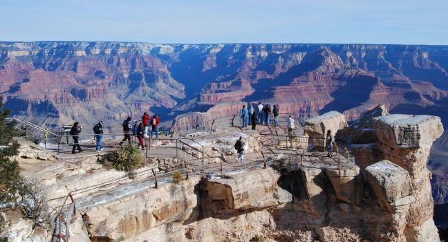
From this elevation of 7,071 feet, you can see a large section of the Colorado River; although it appears as a thin line, the river is nearly 350 feet wide. The overlook extends farther into the canyon than any other point on Hermit Road. The incredible unobstructed views make this a popular place to watch the sunset.

Across the canyon to the north is Shiva Temple. In 1937 Harold Anthony of the American Museum of Natural History led an expedition to the rock formation in the belief that it supported life that had been cut off from the rest of the canyon. Imagine the expedition members' surprise when they found an empty Kodak film box on top of the temple—it had been left behind by Emery Kolb, who felt slighted for not having been invited to join Anthony's tour.

Directly below Hopi Point lies Dana Butte, named for a prominent 19th-century geologist. In 1919 an entrepreneur proposed connecting Hopi Point, Dana Butte, and the Tower of Set across the river with an aerial tramway, a technically feasible plan that fortunately has not been realized.

Mather Point

Fodor's choice

You'll likely get your first glimpse of the canyon from this viewpoint, one of the most impressive and accessible (next to the main visitor center plaza) on the South Rim. Named for the National Park Service's first director, Stephen Mather, this spot yields extraordinary views of the Grand Canyon, including deep into the inner gorge and numerous buttes: Wotans Throne, Brahma Temple, and Zoroaster Temple, among others.

Recommended Fodor's Video

Rim Trail

Fodor's choice

The South Rim's most popular walking path is the 12.8-mile (one-way) Rim Trail, which runs along the edge of the canyon from Pipe Creek Vista (the first overlook on Desert View Drive) to Hermits Rest. This walk, which is paved to Maricopa Point and for the last 1½ miles to Hermits Rest, visits several of the South Rim's historic landmarks. Allow anywhere from 15 minutes to a full day, depending on how much of the trail you want to cover; the Rim Trail is an ideal day hike, as it varies only a few hundred feet in elevation from Mather Point (7,120 feet) to the trailhead at Hermits Rest (6,650 feet). The trail can also be accessed from several spots in Grand Canyon Village and from the major viewpoints along Hermit Road, which are serviced by shuttle buses during the busy summer months. On the Rim Trail, water is available only in the Grand Canyon Village area and at Hermits Rest. Easy.

Yavapai Point

Fodor's choice

Dominated by the Yavapai Geology Museum and Observation Station, this point displays panoramic views of the mighty gorge through a wall of windows. Exhibits at the museum include videos of the canyon floor and the Colorado River, a scaled diorama of the canyon with national park boundaries, fossils, and rock fragments used to re-create the complex layers of the canyon walls, and a display on the natural forces used to carve the chasm. Dig even deeper into Grand Canyon geology with free daily ranger programs. This point is also a good location to watch the sunset.

Desert View Drive

This heavily traveled 25-mile stretch of road follows the rim from the east entrance to Grand Canyon Village. Starting from the less congested entry near Desert View, road warriors can get their first glimpse of the canyon from the 70-foot-tall watchtower, the top of which provides the highest viewpoint on the South Rim. Six developed canyon viewpoints in addition to unmarked pullouts, the remains of an Ancestral Puebloan dwelling at the Tusayan Ruin and Museum, and the secluded and lovely Buggeln picnic area make for great stops along the South Rim. The Kaibab Rim Route shuttle bus travels a short section of Desert View Drive and takes 50 minutes to ride round-trip without getting off at any of the stops: Grand Canyon Visitor Center, South Kaibab Trailhead, Yaki Point, Pipe Creek Vista, Mather Point, and Yavapai Geology Museum.

Desert View Information Center

Near the Desert View Watchtower, this nonprofit Grand Canyon Association store and information center has a nice selection of books, park pamphlets, gifts, and educational materials. It's also a handy place to pick up maps and info if you enter the park at the eastern entrance. All sales from the Association stores go to support park programs.

Desert View Watchtower

From the top of the 70-foot stone-and-mortar watchtower with its 360-degree views, even the muted hues of the distant Painted Desert to the east and the Vermilion Cliffs rising from a high plateau near the Utah border are visible. In the chasm below, angling to the north toward Marble Canyon, an imposing stretch of the Colorado River reveals itself. Up several flights of stairs, the watchtower houses a glass-enclosed observatory with telescopes.

Grand Canyon Verkamp's Visitor Center

This small visitor center is named for the Verkamp family, who operated a curios shop on the South Rim for more than a hundred years. The building serves as an official visitor center, ranger station (get your Junior Ranger badges here), bookstore, and museum, with compelling exhibits on the Verkamps and other pioneers in this region.

Grand Canyon Visitor Center

The park's main orientation center provides pamphlets and resources to help plan your visit. It also holds engaging interpretive exhibits on the park. Rangers are on hand to answer questions and aid in planning canyon excursions. A daily schedule of ranger-led hikes and evening lectures is available, and a 20-minute film about the history, geology, and wildlife of the canyon plays every 30 minutes in the theater. The bicycle rental office, a small café, and a huge gift store are also in this complex. It's a five-minute walk from here to Mather Point, or a short ride on the shuttle bus, which can take you into Grand Canyon Village. The visitor center is also accessible from the village via a leisurely 2-mile walk on the Greenway Trail, a paved pathway that meanders through the forest.

Grandview Point

Grandview Point
Phlens | Dreamstime.com

At an elevation of 7,399 feet, the view from here is one of the finest in the canyon. To the northeast is a group of dominant buttes, including Krishna Shrine, Vishnu Temple, Rama Shrine, and Sheba Temple. A short stretch of the Colorado River is also visible. Directly below the point, and accessible by the steep and rugged Grandview Trail, is Horseshoe Mesa, where you can see remnants of Last Chance Copper Mine.

Grandview Trail

Accessible from the parking area at Grandview Point, the trailhead is at 7,400 feet. The path heads steeply down into the canyon for 3 miles to the junction and campsite at East Horseshoe Mesa Trail. Classified as a wilderness trail, the route is aggressive and not as heavily traveled as some of the more well-known trails, such as Bright Angel and Hermit. There is no water available along the trail, which follows a steep descent to 4,900 feet at Horseshoe Mesa, where Hopi Indians once collected mineral paints. Hike 0.7 mile farther to Page Spring, a reliable water source year-round. Parts of this trail are icy in winter, and traction crampons are mandatory. Difficult.

Arizona, 86023, USA

Hermit Road

The Santa Fe Company built Hermit Road, formerly known as West Rim Drive, in 1912 as a scenic tour route. Nine overlooks dot this 7-mile stretch, each worth a visit. The road is filled with hairpin turns, so make sure you adhere to posted speed limits. A 1½-mile Greenway trail offers easy access to cyclists looking to enjoy the original 1912 Hermit Rim Road. From March through November, Hermit Road is closed to private auto traffic because of congestion; during this period, a free shuttle bus carries visitors to all the overlooks. Riding the bus round-trip without getting off at any of the viewpoints takes 80 minutes; the return trip stops only at Hermits Rest, Pima, Mohave, and Powell Points.

Hermit Trail

Beginning on the South Rim just west of Hermits Rest (and 7 miles west of Grand Canyon Village), this steep, unmaintained, 9.7-mile (one-way) trail drops more than 5,000 feet to Hermit Creek, which usually flows year-round. It's a strenuous hike back up and is recommended for experienced long-distance hikers only; plan for six to nine hours. There's an abundance of lush growth and wildlife, including desert bighorn sheep, along this trail. The trail descends from the trailhead at 6,640 feet to the Colorado River at 2,300 feet. Day hikers should not go past Santa Maria Spring at 5,000 feet (a 5-mile round-trip).

For much of the year, no water is available along the way; ask a park ranger about the availability of water at Santa Maria Spring and Hermit Creek before you set out. All water from these sources should be treated before drinking. The route leads down to the Colorado River and has inspiring views of Hermit Gorge and the Redwall and Supai formations. Six miles from the trailhead are the ruins of Hermit Camp, which the Santa Fe Railroad ran as a tourist camp from 1911 until 1930. Difficult.

Arizona, 86023, USA

Hermits Rest

This westernmost viewpoint and Hermit Trail, which descends from it, were named for "hermit" Louis Boucher, a 19th-century French-Canadian prospector who had a number of mining claims and a roughly built home down in the canyon. The trail served as the original mule ride down to Hermit Camp beginning in 1914. Views from here include Hermit Rapids and the towering cliffs of the Supai and Redwall formations. You can buy curios and snacks in the stone building at Hermits Rest.

Interpretive Ranger Programs

The National Park Service sponsors all sorts of orientation activities, such as daily guided hikes and talks, which change with the seasons. The focus may be on any aspect of the canyon—from geology and flora and fauna to history and early inhabitants. Schedules are available online.

Junior Ranger Program for Families

The Junior Ranger Program provides a free, fun way to look at the cultural and natural history of this sublime destination. These hands-on educational activities for children ages four and up, available at the visitor centers, include guided adventure hikes, ranger-led "discovery" talks, and book readings.

Kolb Studio

The Kolb brothers began building their photographic workshop and residence in 1904, a time when no pipeline meant Emery Kolb descended 3,000 feet each day to get water to develop his prints; he operated the studio until he died in 1976 at age 95. Today the building provides a view of Indian Garden and houses a gallery with paintings, photography, and crafts exhibitions. There's also a small Grand Canyon Association store here. In winter a ranger-led tour of the studio illustrates the Kolb brothers' role in the development of the Grand Canyon. Call ahead to sign up for the tour.

Grand Canyon Village, Grand Canyon National Park, Arizona, 86023, USA
928-638–2771
Sights Details
Rate Includes: Free, Open 8 am; closing fluctuates based on season

Lipan Point

Here, at the canyon's widest point, you can get an astonishing visual profile of the gorge's geologic history, with a view of every eroded layer of the canyon and one of the longest visible stretches of Colorado River. The spacious panorama stretches to the Vermilion Cliffs on the northeastern horizon and features a multitude of imaginatively named spires, buttes, and temples—intriguing rock formations named after their resemblance to ancient pyramids. You can also see Unkar Delta, where a creek joins the Colorado to form powerful rapids and a broad beach. Ancestral Pueblo farmers worked the Unkar Delta for hundreds of years, growing corn, beans, and melons.

Lookout Studio

Built in 1914 to compete with the Kolbs' photographic studio, the building was designed by architect Mary Jane Colter. The combination lookout point, museum, and gift shop has a collection of fossils and geologic samples from around the world. An upstairs loft provides another excellent overlook into the gorge below.

Maricopa Point

This site merits a stop not only for the arresting scenery, which includes the Colorado River below, but also for its view of a defunct mine operation. On your left, as you face the canyon, are the Orphan Mine, a mine shaft, and cable lines leading up to the rim. The mine, which started operations in 1893, was worked first for copper and then for uranium until the venture came to a halt in 1969. Little remains of the mine infrastructure today, but some displays along the Rim Trail discuss its history. The Battleship, the red butte directly ahead of you in the canyon, was named during the Spanish-American War, when warships were in the news.

Mohave Point

Some of the canyon's most magnificent stone spires and buttes visible from this lesser-known overlook include the Tower of Set; the Tower of Ra; and Isis, Osiris, and Horus temples. From here you can view the 5,401-foot Cheops Pyramid, a grayish rock formation behind Dana Butte, plus some of the strongest rapids on the Colorado River.

Moran Point

This point was named for American landscape artist Thomas Moran, who was especially fond of the play of light and shadows from this location. He first visited the canyon with John Wesley Powell in 1873. "Thomas Moran's name, more than any other, with the possible exception of Major Powell's, is to be associated with the Grand Canyon," wrote noted canyon photographer Ellsworth Kolb. It's fitting that Moran Point is a favorite spot of photographers and painters.

Navajo Point

A possible site of the first Spanish view into the canyon in 1540, this overlook is also at the highest natural elevation (7,461 feet) on the South Rim.

Pima Point

Enjoy a bird's-eye view of Tonto Platform and Tonto Trail, which winds its way through the canyon for more than 70 miles. Also to the west, two dark, cone-shaped mountains—Mount Trumbull and Mount Logan—are visible on the North Rim on clear days. They rise in stark contrast to the surrounding flat-top mesas and buttes.

Powell Memorial

A granite platform honors the memory of John Wesley Powell, who measured, charted, and named many of the canyons and creeks of the Colorado River. It was here that the dedication ceremony for Grand Canyon National Park took place on April 3, 1920.

South Kaibab Trail

This trail starts near Yaki Point, 4 miles east of Grand Canyon Village, and is accessible via the free shuttle bus. Because the route is so steep (and sometimes icy in winter)—descending from the trailhead at 7,260 feet down to 2,480 feet at the Colorado River—many hikers take this trail down, then ascend via the less demanding Bright Angel Trail. Allow four to six hours to reach the Colorado River on this 6.4-mile trek. At the river, the trail crosses a suspension bridge and runs on to Phantom Ranch. Along the trail there is no water and little shade. There are no campgrounds, though there are portable toilets at Cedar Ridge (6,320 feet), 1½ miles from the trailhead. An emergency phone is available at the Tipoff, 4.6 miles down the trail (3 miles past Cedar Ridge). The trail corkscrews down through some spectacular geology. Look for (but don't remove) fossils in the limestone when taking water breaks. Difficult.

Arizona, 86023, USA

The Abyss

At an elevation of 6,720 feet, the Abyss is one of the most awesome stops on Hermit Road, revealing a sheer drop of 3,000 feet to the Tonto Platform, a wide terrace of Tapeats sandstone about two-thirds of the way down the canyon. From the Abyss you'll also see several isolated sandstone columns, the largest of which is called The Monument.

Trailview Overlook

Look down on a dramatic view of the Bright Angel and Plateau Point trails as they zigzag down the canyon. In the deep gorge to the north flows Bright Angel Creek, one of the region's few permanent tributary streams of the Colorado River. Toward the south is an unobstructed view of the distant San Francisco Peaks, as well as Bill Williams Mountain and Red Butte.

Tusayan Ruin and Museum

This museum offers a quick orientation to the prehistoric and modern indigenous populations of the Grand Canyon and the Colorado Plateau, including an excavation of an 800-year-old Pueblo site. Of special interest are split-twig figurines dating back 2,000 to 4,000 years and other artifacts left behind by ancient cultures. A ranger leads daily interpretive tours of the Ancestral Pueblo village.

Arizona, 86023, USA
928-638–7888
Sights Details
Rate Includes: Free