Hiking
Your most memorable Yellowstone moments will likely take place along a hiking trail. Encountering a gang of elk in the woods is unquestionably more exciting than watching them graze on the grasses of Mammoth Hot Springs Hotel. Hearing the creak of lodgepole pines on a breezy afternoon feels more authentic than listening to tourists chatter as you jockey for the best view of Old Faithful. Even a one-day visitor to Yellowstone can—and should—get off the roads and into the "wilderness." Because the park is a wild place, however, even a ½-mile walk on a trail puts you at the mercy of nature, so be sure to prepare yourself accordingly. As a guide on an Old Yellow Bus Tour said, "You don't have to fear the animals—just respect them."
No matter how short the hike, the following items are essential, not discretionary, especially if you're venturing into the backcountry and away from developed areas:
Bear spray. At $50 a can and sold in the park, it's not cheap, but it's a critical deterrent if you run into one. Learn how to use it, too.
Food and water. Your "meal" can be as simple as a protein bar and a bottle of water if you're hiking only a mile or two, but for hikes of an hour or longer, it's critical to head out with an ample supply of drinking water and a variety of snacks.
Appropriate clothing. Watch the forecast closely (available at every lodging office and visitor center). Bring a layer of clothing for the opposite extreme if you're hiking at least half the day. Yellowstone is known for fierce afternoon storms, so be ready with gloves, hat, and waterproof clothing.
Altitude awareness. Much of Yellowstone lies more than 7,500 feet above sea level. The most frequent incidents requiring medical attention are respiratory problems, not animal attacks. Be aware of your physical limitations—as well as those of your young children or elderly companions.
Hiking Tours
Heart Lake
Old Faithful
Easy
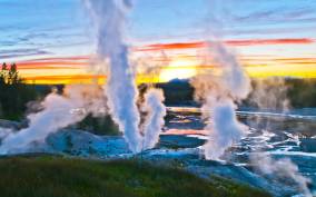
Fountain Paint Pots Nature Trail. Take the ½-mile loop boardwalk to see the fumaroles (steam vents), blue pools, pink mudpots, and mini-geysers in this thermal area. The trail is popular, and sometimes a bit overcrowded, in summer and winter because it's so accessible. Easy. Yellowstone National Park, Wyoming.
Moderate
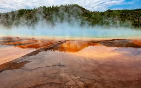
Mystic Falls Trail. From the west end of Biscuit Basin boardwalk, this 2.4-mile round-trip trail climbs gently for a mile through heavily burned forest to the lava-rock base of 70-foot Mystic Falls. It then switchbacks up Madison Plateau to a lookout with the park's least-crowded view of Old Faithful and the Upper Geyser Basin. Easy–Moderate. Old Faithful, Yellowstone National Park, Wyoming.
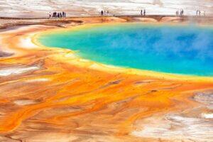
Observation Point Loop. A 2-mile round-trip route leaves Geyser Hill Loop boardwalk and becomes a trail shortly after the Firehole River; it circles a picturesque overview of Geyser Hill with Old Faithful Inn as a backdrop. You may also see Castle Geyser erupting. Even when 1,000-plus people are crowded on the boardwalk to watch Old Faithful, expect to find fewer than a dozen here. Easy–Moderate. Old Faithful, Yellowstone National Park, Wyoming.
Madison and Norris
Easy
Back Basin–Porcelain Basin Loops. You can hike these two easy loops, which both leave from the Norris Ranger Station, in under two hours. The 1½-mile Back Basin loop passes Emerald Spring, Steamboat Geyser, Cistern Spring, and Echinus Geyser. The latter was long known as Norris's most dependable big geyser, but its schedule has become much more erratic. The ¾-mile Porcelain Basin loop leads past whitish geyserite stone and extremely active Whirligig and other small geysers. Easy. Norris, Yellowstone National Park, Wyoming.
Moderate
Mammoth Hot Springs
Moderate
Beaver Ponds Loop Trail. This 2½-hour, 5-mile loop starts at Liberty Cap in the busy Lower Terrace of Mammoth Hot Springs. Within minutes you'll find yourself amid the park's dense backcountry as you climb 400 feet through spruce and fir, passing several ponds and dams, as well as a glacier-carved moraine, before emerging on a windswept plain overlooking the Montana–Wyoming border. Look up to see Everts Peak to the east, Bunsen Peak to the south, and Sepulcher Mountain to the west. Your final descent into Mammoth Springs has great views of Mammoth Springs. Moderate. Mammoth Hot Springs, Yellowstone National Park, Wyoming.
Bunsen Peak Trail. Past the entrance to Bunsen Peak Road, this moderately challenging 4.4-mile round-trip trek climbs 1,280 feet to 8,527-foot Bunsen Peak for a dramatic panoramic view of Blacktail Plateau, Mammoth Hot Springs, the Gallatin Mountains, and the Yellowstone River valley. Allow about three hours.Moderate–Difficult. Yellowstone National Park, Wyoming.
Difficult
Tower-Roosevelt
Moderate
Slough Creek Trail. Starting at Slough Creek Campground, this trail climbs steeply along a historic wagon trail for 1½ miles before reaching expansive meadows and prime fishing spots, where moose are common and grizzlies occasionally wander. Allow two or three hours for the full 3.4-mile round-trip hike. Moderate. Yellowstone National Park, Wyoming.
Canyon
Easy
Mud Volcano Trail. This 0.6-mile loop hike in Hayden Valley curves gently around seething, sulfuric mudpots with such names as Sizzling Basin and Black Dragon's Cauldron, and around Mud Volcano itself. Easy. Canyon, Yellowstone National Park, Wyoming.
Moderate
Brink of the Lower Falls Trail. Especially scenic, this short but steep jaunt branches off of the North Rim Trail and can be accessed from either the Brink of the Upper Falls or Brink of the Lower Falls parking areas. The ½-mile one-way trail switchbacks 600 feet down to within a few yards of the top of the Yellowstone River's 308-foot Lower Falls. Moderate. Yellowstone National Park, Wyoming.
North Rim Trail. Offering great views of the Grand Canyon of the Yellowstone, the 3-mile (each way) North Rim Trail runs from Inspiration Point to Chittenden Bridge. Particularly fetching is the ½-mile section of the North Rim Trail from the Brink of the Upper Falls parking area to Chittenden Bridge that hugs the rushing Yellowstone River as it approaches the canyon. This trail is paved and fully accessible between Lookout Point and Grand View, and it can be accessed at numerous points along North Rim Drive. Moderate. Yellowstone National Park, Wyoming.
South Rim Trail. Partly paved and fairly flat, this 1¾-mile trail along the south rim of the Grand Canyon of the Yellowstone affords impressive views and photo opportunities of the canyon and falls of the Yellowstone River. It starts at Chittenden Bridge, passes by magnificent Upper Falls View and Uncle Tom's Trail, and ends at Artist Point. Beyond Artist Point, you can continue your adventures for another 1.3 miles along a less-traveled and stunning trail to Point Sublime, or cut inland through high mountain meadows along the Clear Lake–Ribbon Lake Loop. You'll see fewer humans and possibly more wildlife in this more rugged backcountry, so carry bear spray. Moderate. Canyon, Yellowstone National Park, Wyoming.
Difficult
Uncle Tom's Trail. Accessed by the South Rim Drive, this spectacular and strenuous 700-step trail ½ mile east of Chittenden Bridge descends 500 feet from the parking area to the roaring base of the Lower Falls of the Yellowstone. Much of this walk is on steel sheeting, which can have a film of ice during early summer mornings or anytime in spring and fall. Moderate–Difficult. Yellowstone National Park, Wyoming.
Lake Area
Easy
Storm Point Trail. Well marked and mostly flat, this 2.3-mile loop leaves the south side of the road for a perfect beginner's hike out to Yellowstone Lake, particularly with a setting sun. The trail rounds the western edge of Indian Pond, then passes moose habitat on its way to Yellowstone Lake's Storm Point, named for its frequent afternoon windstorms and crashing waves. Heading west along the shore, you're likely to hear the shrill chirping of yellow-bellied marmots. Also look for ducks, pelicans, trumpeter swans, and bison. You'll pass several small beaches that kids enjoy exploring. Easy. Fishing Bridge, Yellowstone National Park, Wyoming.
Difficult
Avalanche Peak Trail. On a busy day in summer, only a handful of parties will fill out the trail register at the Avalanche Peak trailhead, so if you're seeking solitude, this is your hike. Starting across from a parking area on the East Entrance Road, this rigorous 4.2-mile, four-hour round-trip climbs 2,150 feet to the peak's 10,566-foot summit, from which you'll see the rugged Absaroka Mountains running north and south. Look around the talus and tundra near the top of Avalanche Peak for alpine wildflowers and butterflies. From early September to late June, the trail is often impassable due to snow, and fall also can see grizzly bear activity. Stick to summer. Difficult. Fishing Bridge, Yellowstone National Park, Wyoming.