

Walk, don’t drive, across these bridges for peak views of New York City.
New York City has fabulous views, but many are only seen from skyscraper rooftops, restaurant terraces, or well-worn tourist attractions. In other words, they can all come with hefty entrance fees.
An alternative: walk across one of the dozens of NYC’s pedestrian bridges, which charge no fee (even those that charge tolls to vehicles), are entirely open-air (ideal for the COVID-cautious), and offer some of the most spectacular water and city views. Plus, many of these pedestrian bridges are historic, dating back decades or even centuries, with period details best appreciated up close.
While scores of bridges connect the five boroughs of NYC or connect the city to surrounding areas such as New Jersey, many are strictly for vehicular traffic. The following bridges all have pedestrian paths, giving urban hikers (and bikers) room to explore.
Top Picks for You
Brooklyn Bridge
Connects: Manhattan (City Hall/Financial District) and Brooklyn (Brooklyn Heights)
Length: 6,016 feet (about 1.1 mile)
If you can walk only one bridge, this is the one—since the wooden promenade is above six lanes of car traffic, there’s plenty of light and room to walk (bike, scoot, or skateboard). Constructed between 1869 and 1883 (with a massive reconstruction between 1944 and 1954, when railroad and trolley tracks were removed), this suspension bridge was the first roadway to connect Manhattan and Brooklyn over the East River. It’s spectacular to behold from a distance, especially from Brooklyn Bridge Park and while crossing. The detail of the Gothic towers and spiderweb-like steel cables are worth seeing up close, so don’t forget to look up now and then in between gawking at the Freedom Tower and the Statue of Liberty.
INSIDER TIPThis iconic bridge draws plenty of selfie-seekers and group photo ops, not to mention runners/bikers and commuters. Go early on the weekend to avoid the crowds.
Ed Koch Queensboro Bridge/59th St
Connects: Manhattan (Midtown/Sutton Place) and Queens (Long Island City)
Length: 7,449 feet (about 1.4 miles)
Disregard the mellow vibes of The 59th Street Bridge Song (Feelin’ Groovy). No disrespect meant to Simon & Garfunkel, but walking across this bridge—opened in 1909 and also known as the 59th Street Bridge— can be a bit nerve-wracking, as it’s a narrow and well-trafficked expanse, with pedestrians and cyclists sharing a single lane on the northern side of the bridge. Don’t let that deter you from enjoying the East River expanse and a birds-eye view of Roosevelt Island. Some relief is on the way: a separate bicycle lane on the southern side is in the works, estimated to be completed by the end of 2023.
INSIDER TIPThe bridge is embedded in mid-century pop culture. In addition to the Simon & Garfunkel song, it’s a backdrop in the film ‘Manhattan’ and seen on a loop in the opening credits for ‘Taxi.’
Recommended Fodor’s Video
George Washington Bridge
Connects: Manhattan (Washington Heights) and Fort Lee, New Jersey
Length: 4,760 feet (about 0.9 miles)
Crossing the Hudson River between New York and New Jersey, the mighty GW first opened to traffic in 1931. Since then, it’s expanded to become a double-decker suspension bridge (the lower deck opened in the early 1960s) and is one of the busiest bridges in the world. It’s challenging to walk if only because until an anticipated bike lane is completed in 2025(!), the walkway on the south side of the bridge must accommodate both pedestrians and bikers. Look over your shoulder to avoid bicycles coming up behind you. There are a couple of spots with extra space to stop for a breather and take photos of the cliffs of the Palisades on the Jersey side or clear down the west side of Manhattan.
INSIDER TIPTake a breather on either end of the bridge: on the Jersey side, detour to Fort Lee Historic Park; on the NYC side, visit the Little Red Lighthouse in Fort Washington Park (there’s a children’s book about it too).
High Bridge
Connects: Manhattan (Washington Heights) and the Bronx (Highbridge)
Length: 1,450 ft (about 0.27 miles)
NYC’s oldest standing bridge opened in 1848 as part of the Croton Aqueduct system, which carried water from the Croton River down to Manhattan; the walkway across the Harlem River was completed in 1864. Although the bridge fell into disrepair, leading to its closure in the 1970s, the bridge and neighboring parks were restored to their 19th-century glory and re-opened to the public in 2015. Today, it’s easy to imagine Victorian-era sightseers strolling along the esplanade (illustrations on historical plaques embedded in the walkway help provide a little visual assist). Take photos of the picturesque water tower in Highbridge Park, installed in 1872; in 1958, a five-octave carillon was added, part of a refurb financed by department store magnate B. Altman. Comfortably wide on-ramps and zero car traffic make this a particularly wheelchair-accessible bridge.
INSIDER TIPAfter crossing the bridge toward Manhattan, consider exploring Highbridge Park, which includes some short dirt-trail paths in a wooded area that almost feels like you’re not in NYC.
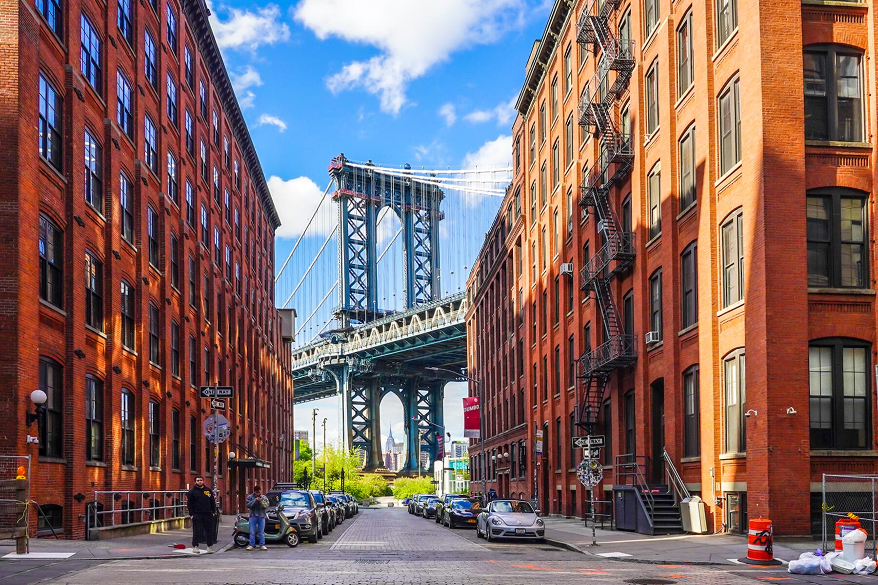
Manhattan Bridge
Connects: Manhattan (Chinatown) and Brooklyn (Dumbo)
Length: 6,090 feet (about 1.2 miles)
Built in 1909, this suspension bridge offers a utilitarian walk across the East River. The dedicated pedestrian walkway is nice, but movement from the subway and car traffic may encourage you to hurry along between glimpses of the Statue of Liberty, New York Harbor, and Brooklyn Bridge. Frankly, the bridge is best appreciated from a distance: admire the Manhattan entrance, with its elaborate stone portal and sprawling plaza, designed by Carrère and Hastings, the architectural team who also designed the main branch of the New York Public Library. From Brooklyn, you’ll have a better vantage point to enjoy the ornamented towers and graceful sweep of the bridge.
INSIDER TIPHow to tell between the adjacent Brooklyn and Manhattan bridges (an area real estate developers have now dubbed “Two Bridges”)? Remember this pneumonic: “B is built of bricks, M is made of metal.”
Marine Parkway-Gil Hodges Memorial Bridge
Connects: Queens (Rockaway Peninsula) and Brooklyn (Floyd Bennett Field/Marine Park)
Length: 4,022 feet (about 0.76 miles)
Sure, you can take a ferry to the Rockaways. But this bridge over the Rockaway Inlet in Jamaica Bay offers another way to get there. Completed in 1937 to encourage visitors to newly-built Jacob Riis Park, this lift bridge was designed with tapered towers topped with a curved, wheel-like design, intended to suggest the wheels that elevate the bridge (some might liken them to the curls of seashells). In 1978, Gil Hodges’ name was added to the bridge; the New York ball legend played first base for the former Brooklyn Dodgers as well as managed for the Mets. (However, most still call it the Marine Parkway Bridge.) For those on foot or bikes, it’s a nice little add-on jaunt if you’re headed to the beach, with vast water views unhampered by steel-fence grids. On a clear day, peer toward Brooklyn, and you’ll spy the tallest towers of Manhattan off in the distance.
INSIDER TIPKeep an eye out for Peregrine falcons. The endangered birds nest in the towers, with the blessing of the MTA and the NYC Department of Environmental Protection.
Pulaski Bridge
Connects: Queens (Long Island City) and Brooklyn (Greenpoint)
Length: 2810 feet (about 0.5 miles)
Opened in 1954, this drawbridge was named for Casimir Pulaski, a Polish-born Revolutionary War hero who fought alongside George Washington, a nod to Greenpoint’s large Polish population. (More recently, Pulaski has made headlines amid speculation that the cavalry leader may have been female or intersex.) Those walking the bridge over Newton Creek and the Long Island Expressway may notice that it’s painted “Pulaski Red” (one of several official bridge-paint colors used by the Department of Transportation; see also George Washington Bridge Gray and Brooklyn Bridge Tan), as is detailing on the art deco-inspired watchtower at the center of the bridge. The area around the outlook building is the best spot to linger for photos or to gaze at the boats bobbing in Newtown Creek, a reminder of NYC’s maritime history.
Robert F. Kennedy Bridge; Harlem River Lift Bridge
Connects: Manhattan (East Harlem) and Randall’s Island
Length: 4,150 feet (about 0.78 miles)
Known as the Triborough Bridge until 2008, the OG name says it all: it’s actually three bridges connecting three boroughs (Manhattan, Queens, and the Bronx). Yes, you can walk all three (about 3.3 miles total), but you don’t have to do them all at once. For pedestrians, all three bridges connect in Randall’s Island.
We suggest the Harlem River Lift Bridge (meaning the flat expanse can lift straight up to allow boats to pass underneath). Embarking at 2nd Ave and 125th Street means pleasant views of the Harlem River, parkland on Randall’s Island, and Astoria off in the distance. When the bridge drops off on Randall’s Island, you can decide whether to relax there for a while or continue on via the Randalls Island Connector (to Port Morris, Bronx) or the East River Suspension Bridge (the longest part, which connects to Astoria, Queens).
INSIDER TIPRandall’s Island and Wards Island connect so you can walk on via the RFK and exit via the Wards Island Bridge (see below).
Roosevelt Island Bridge
Connects Queens (Astoria) and Roosevelt Island
Length: 2,877 feet (about 0.5 miles)
Built in 1955, this bridge is the only way to drive onto Roosevelt Island and includes a pedestrian sidewalk (the tram overhead is another option). The vertical lift bridge has kind of an industrial mood, thanks to the faded red paint and power-plant views on the Queens side. Wave hello to Big Allis, the four red-and-white candy-cane-striped smoke stacks rising from the Ravenswood Generating Station, a local landmark.
Wards Island Bridge
Connects Manhattan (East Harlem) and Wards Island
Length: 1,247 feet (about 0.24 miles)
The mint-green Wards Island Bridge, also known as the 103rd Street Footbridge, may be the most relaxing to stroll across. It’s strictly a pedestrian bridge–no cars to dodge. And the island–technically part of Manhattan–is a chill place to spend an afternoon, home to mostly parkland. This is the second iteration of the bridge, completed in 1951, after the 1807 original, a wooden drawbridge, was destroyed by a storm.
INSIDER TIPTake the NYC Ferry to East 90th Street for maximum waterfront views, then walk along the waterfront to the bridge entrance at 103rd St.
Williamsburg Bridge
Connecting Manhattan (Lower East Side) and Brooklyn (Williamsburg)
Length: 7,308 feet (about 1.39 miles)
The Williamsburg bridge should be required walking for art-lovers–graffiti is underfoot and splashed on walls; murals greet you on the Brooklyn side; unexpected artistic displays pop up where you least expect, such as intertwined on chain-metal fencing. This suspension bridge opened in 1903, one of the last bridges designed to convey horse and carriage and, later, trolleys. It’s now one of the busiest bridges for car traffic and has separate lanes for pedestrians and cyclists.