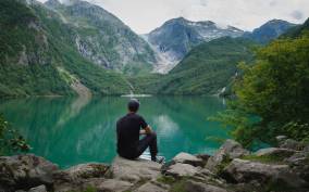
Hiking
Like most Norwegians, Bergensers love to go hiking, especially on one of the seven mountains that surround the city.
Bergen og Hordaland Turlag (DNT). The Norwegian Trekking Association arranges hikes and maintains cabins for hikers. You can pick up maps of many self-guided walking tours from the office, as well as from local bookstores. Tverrgt. 4–6, Sentrum, Bergen, Hordaland, 5017. 55–33–58–10; www.bergenoghordalandturlag.no.
Mt. Fløyen. Take the funicular up Mt. Fløyen, and minutes later you'll be in the midst of a forest. From the nearby shop and restaurant, well-marked paths fan out over the mountains. Follow Fløysvingene Road down for an easy stroll, with great views of the city and harbor. Vetrlidsallmenningen 21, Bryggen, Bergen, Hordaland, 5014. 55–33–68–00; floyen.no.
Mt. Ulriken. Mt. Ulriken is popular with walkers and hikers of all levels. The easiest way to reach the summit is via the cable car from Haukeland University Hospital. (To get there, take the double-decker bus that leaves from Torget every day between May and September.) Once you get off the cable car, you'll find trails leading across the mountain plateau, Vidden, which is above the tree line. The plateau connects the Fløyen and Ulriken mountains, and you can hike between them in four to six hours. Views from the alpine trail are spectacular. Be advised that foggy and rainy weather, even in the summer months, can make hiking here dangerous. Consult the tourist information center in Bergen for maps and general advice. Mt. Ulriken, 53–64–36–43; www.ulriken643.no.