


Take an amazing global adventure at the click of a mouse.
Google Street View launched in 2007 with just a few U.S. cities. Well, as they say, it’s come a long way, baby. This popular map imagery tool literally has since expanded around the planet (and beyond!), with images captured by a camera-equipped car, aerial drones, on-foot trekkers—even a camera-toting dog. Traverse the dusty lanes of Kruger NP in search of elephant, climb a granite monolith in Yosemite NP, explore the Bedouin world of the Liwa Desert in UAE—and so much more. All it takes is a click of the mouse and away you go, on some of the best adventures you’ve ever had without leaving home.
INSIDER TIPClick on the little orange man in the box at the lower left of your screen to position the view to where you would like to explore. The blue lines are the places that have been captured.
Kruger National Park, South Africa
Kruger is a Noah’s ark of wildlife, where you can hop aboard a safari jeep and spot lurking elephants, graceful giraffes, prowling lions, and at least 144 other species both large and small. Google Street View takes you down the park’s dusty roads and dry creek beds in the vicinity of Letaba Camp, and you find yourself keeping an eye out for elephants and hippos. You’ll spot them, and get the same high as you would on a real safari.
INSIDER TIPAll of South Africa’s national parks are now available via Google Street View.
Tangier Island, Chesapeake Bay, Virginia
This remote island in the middle of Chesapeake Bay is home to the legendary watermen—the hardcore men and women who for centuries have harvested the bay’s oysters and crabs. The island is so isolated they still speak with what some describe as the distinct Old English accent of their forebears. With Google Street View, you can explore every trail, road, beach, and public pier, taking in the isle’s bird-filled marshlands, streets roamed by golf carts (there are no cars), and prim and proper New England-style homes of its close-knit community. You can even travel on the channel in and out of the harbor—the watermen’s main street. One thing you’ll notice (aside from the Chesapeake views at nearly every turn) are the weathered tombstones in everyone’s front yard. Since the island is so low-lying (and rapidly eroding), graves must be built above ground. Climate change is real here.
Recommended Fodor’s Video
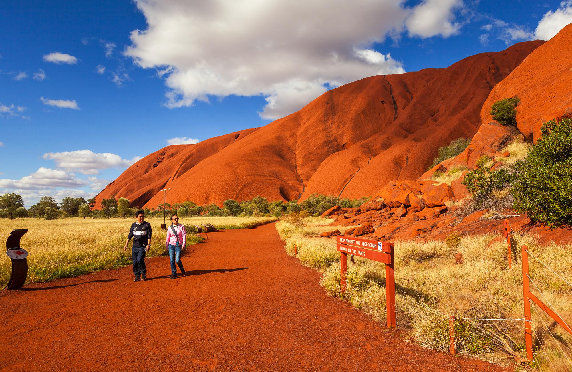
Uluru–Kata Tjuta National Park, Australia
The red-rock centerpiece of this national park rises high above the Australian bush, long a sacred site of the Anangu people. The world’s oldest continuing culture, they believe their ancestral beings created the landscape at the beginning of time, and they continue to practice ancient laws and traditions passed down for thousands of years from one generation to the next. With Google Street View, created in collaboration with the Anangu, you can take a virtual walk on the Kuniya trail around the circumference, viewing the hallowed icon from nearly every angle (some are deemed too sacred to allow cameras). But what truly adds to the experience is the 360-degree Story Spheres, interactive videos showcasing the traditional Anangu storytelling and music.
Yosemite National Park, California
A sheer granite monolith towering high above Yosemite Valley, El Capitan is one of the world’s most stunning natural wonders. Astoundingly, hardcore climbers scramble up its rock face, camping out on narrow ledges when night sets in. With Google Street View, you can take in the climber’s harrowing perspective with 360-degree views of the spectacular scenery around you, captured by world-famous rock-jocks Alex Honnold, Tommy Caldwell, and Lynn Hill. You’ll find yourself catching your breath as they contemplate their next moves, wondering how any human possibly could scramble up such vertical walls of rock.
Iguazú Falls, Argentina
The world’s largest waterfall system, Iguazú Falls straddles the Argentina and Brazil border, demonstrating an extravagant display of watery power. Rainbows are everywhere (as are the cute little coatis). With Google Street View, you’re on the edge of the Iguazú River as it plunges over the escarpment, on its misty trails taking in the falls from afar, even aboard a boat approaching the wall of water at its base. The only thing missing? The cool spray of water and the thundering noise of crashing waters.
Fontevraud Royal Abbey, France
Abbeys were more than religious centers during the Middle Ages. They were meeting places for the era’s greatest minds, making huge advancements in academics, agriculture, technology, even hospitality. (That said, some might argue their greatest contributions are the world’s most delectable cheeses, wine, and beer!) With Google Street View, you can explore Fontevraud Royal Abbey in the Loire Valley, one of France’s largest surviving medieval monastic cities. As you virtually stroll along, you’ll take in its medieval architecture (including the gorgeous cloisters), beautiful frescoes, even a prison exhibit.
Odate City, Japan
Google Street Views are captured via cameras typically strapped to humans one way or another. Well, Google has recently introduced a tour of Odate City, known as the birthplace of the Akita Inu dog. And what better way to visit than from a local dog’s perspective? Indeed, a camera was harnessed to the backs of two of the fluffy canines, who proudly trotted around town, providing a 360-degree, pup’s-eye view of a snowy mountain trail, an open-air hot spring, and the bronze statue of Hachiko, an Akita that garnered fame for its loyalty, among other attractions. It’s a dog’s world, as they say.
Karlův most (Charles Bridge), Prague, Czech Republic
Prague’s famous bridge dates back to the Holy Roman Emperor (and Czech king) Charles IV, who initiated it in 1357. A parade of baroque statues edge both sides, the most popular of which is probably St. John of Nepomuk, the Czech martyr who was tossed off the bridge to his death during the reign of Wenceslas IV. With Google Street View, you can wander across the bridge, studying the statues in detail, checking out the work of local artists, seemingly getting lost in the crowd. The scenes switch between night and day, providing different takes on Prague (or at least tourist Prague) life.
Liwa Desert Oasis, UAE
Seemingly endless dunes stretch across the vast Liwa Desert, located about 60 miles south of the Persian Gulf. Here you’ll find the Liwa Desert Oasis, a collection of 50 villages where Abu Dhabi and Dubai royalty have been born for centuries. Google Street View allows you to explore this mystical land, coming across camels, date farms, Bedouin settlements, and lots of empty sandscapes. The footage was mapped from a camera mounted atop a camel—giving the scenes a truly authentic sense of traveling in the area.
Venice, Italy
In a city without cars, what better way to explore than by boat? And since it’s Venice, might as well make it a gondola. With Google Street View, you can do just that, weaving among ferries and barges as you take in 360-degree views of St. Mark’s Square, the famous Rialto Bridge, and more, all pieced-together panoramas shot from a veritable gondola. But it’s not all about the water. There are narrow lanes to be explored as well with their cultural treasures, including Teatro La Fenice, where many notable operas debuted; and Basilica di Santa Maria Gloriosa dei Frari, famed for its Renaissance masterpieces.
International Space Station
Google Street View doesn’t restrict itself to planet Earth. In what’s got to be one of the coolest projections, you can poke around the International Space Station—the largest man-made structure ever put into space. You can explore everything from the state-of-the-art Columbus Research Laboratory to the astronauts’ sleeping quarters—all 15 modules in all, as well as Space X’s Dragon spacecraft. Click on nifty little dots for explanations of what everything does.
Use of these maps is subject to the Google Privacy Policy.