

Gaborone to Victoria Falls in the footsteps of Major Stabb Part 1
 May 5th, 2022, 12:33 AM
#1
Original Poster
Join Date: May 2022
Posts: 23
Likes: 0
Received 0 Likes
on
0 Posts
Gaborone to Victoria Falls in the footsteps of Major Stabb Part 1
This is a trip report with a difference.
To visit Victoria Falls today requires little more than a passport and a credit card. There are international airports in Livingstone (Zambia), Victoria Falls (Zimbabwe) and Kasane (Botswana). Tourist operators will collect you at any of these airports and whisk you off to the Falls in air-conditioned comfort. In theory you could be back at Heathrow within 48 hours of leaving England, so it would be possible to travel from Devonshire to the falls and back over a Bank Holiday Weekend.
But it wasn�t always so. Amongst the first ten tourists to visit the Victoria Falls was a native of Ilfracombe, Major Henry Stabb (1835-1888). He left an account of his travels in his diary, published posthumously in 1967.
I�ve always been fascinated by the exploits of the early self-drive tourists in Bechuanaland, so I decided to follow in Major Stabb�s footsteps. His notes on the trip amount to 490 pages and they are very detailed. He presumably had ambitions of publishing the diary one day himself, as he had marked some pages relating to the drinking behavior and other foibles of people he encountered with the annotation �LEAVE OUT�. By 1967 all of those mentioned would have been long dead, so the publishers left these pages in, giving us a wonderfully vivid window into life beyond the frontier.
My own notes were made between June 2020 and March 2022. Movement restrictions during the Covid-19 pandemic meant I could follow Major Stabb�s route only piecemeal as and when the opportunity arose. It would be much easier to follow his route today: Fully vaccinated travelers can now move about Southern Africa quite freely, just as we could before the pandemic. Such is life.
But let me begin with a little about Major Stabb himself
Charles Henry Sparke Stabb was born in Ilfracombe, Devon, in 1835. He was commissioned into the 32nd Foot (Duke of Cornwall�s Light Infantry) in 1856 and served in both India and Mauritius before being posted to King William�s Town in the Cape Colony.
In March 1875 he rook extended leave from his regiment to tour the �far interior� and visit the Victoria Falls. At that time fewer than fifty Europeans had seen the Falls, and of these only a handful could be described as tourists. The remainder were traders, missionaries or professional hunters who were passing by on business. But Major Stabb was very definitely a �self drive tourist�. He simply wanted to see the Victoria Falls. He and his friend Captain James Glascott bought an ox-wagon and 12 oxen. They engaged a wagon driver and a guide. Each took a soldier-servant. And they set off to the north. The wagon driver, who had an alcohol problem, was discharged in Bloemfontein and one of the soldiers drove the wagon thereafter, so they were traveling as a party of 5.
Eight weeks after leaving King William�s Town the little party arrived in Zeerust, near the modern day border between South Africa and Botswana. And this is where his diary really begins.
In 1875 the Bechuanaland Protectorate lay 10 years in the future. What is now Botswana was just a sparsely populated territory ruled by various Tswana tribes. The countries we know today as Zambia and Zimbabwe that lay beyond were untracked and unmapped. No guidebooks and no travel agents.
25 May 1875: �Zeerust is a queer little place�It is one of the most primitive places in the world, but as the frontier town in the Transvaal we see here the last traces of the civilisation we leave behind us.�
Any tourists keen to see Zeerust for themselves can easily take a rental car from Sir Seretse Khama International Airport in Gaborone, enjoy the scenic drive south to the historic town of Lobatse, and join the long queue at the Ramatlabama border post. Zeerust lies about 50 km further on. But Major Stabb, if he returned to Zeerust today might not feel inclined to change his original description. It remains a slightly wild, dusty place with very little to interest a tourist.Stabb and Glascott took time out to attend a local wedding.
Luncheon discussed and ovceans of fizz consumed, to say nothing of brandy and soda, beer and such like beverages, an attempt at dancing was made, but the only music being a concertina, the only dance a mazurka and the only floor a mud one, it soon degenerated into a romp, the great aim and object of which appeared that each gentleman should kiss as many ladies as he could �.
They then set off from Zeerust for the Notwane River and the wilds of Bechuanaland.
The little party was in a hurry. An oxcart can make only about 14 miles per day and they had only 8 months leave. So they
didn�t linger when they reached the river. But it is certainly worth lingering today. The river has been dammed in several places and the dams are much loved recreational assets for the residents of Gaborone. I�m not a member of the Gaborone Yacht Club (though I was a member of the Niue Yacht Club for a time), but fortunately the restaurant is open to all comers. 200g of rump steak with chips and salad for < US$10 is good value. And the view from the deck alone is worth every cent. If you Google �Happy Muncher Gaborone Yacht Club� you will find a video posted by an enthusiastic local patron.
The Notwane Dam is older, and surrounded by forest teeming with wildlife. There are Nile crocodiles, huge water monitor lizards, chacma baboons, vervet monkeys, kudu and duiker along the banks. The birdlife is amazing. There is a lot of historical interest here too, including a famous Boer War battlefield. We don�t have our own boat but were able to explore the shores with Crocodile Pools River Safaris. Very good value at about US$25 pp for an afternoon cruise.
We camped overnight at the Mokolodi Nature Reserve, cooked over a campfire and had our dinner stolen by a black-backed jackal and a vervet monkey made off with some of our breakfast. Some things haven�t changed since 1875 !

 May 25th, 2022, 08:47 AM
#4
Original Poster
Join Date: May 2022
Posts: 23
Likes: 0
Received 0 Likes
on
0 Posts
In the Footsteps of Major Stabb Part 3: Shoshong
Henry Stabb and James Fairbairn reached Shoshong on the 18th of June 1875.
The town which is the capital of the Bamangwato country and in which we now find ourselves is called in the map Shoshong and to me, being the first of the kind that I have seen, was interesting enough. It is however merely composed of a large collection of huts, apparently at first glance huddled closely together without any regard to arrangement and order and containing a population of perhaps 20,000. The whole town is surrounded by a thick hedge of thorns, erected at considerable labour as a bulwark of defence both against surprises by a hostile tribe and against depredations of wild animals�The situation of the town has been chosen with a view of defence. It is built at the base of a range of hills and runs back up a deep gorge which leads to the only fountain of water known in the neighbourhood.�
The Shoshong hills are still there. The hills and gorges teem with wildlife, and the old tracks through the hills have much to offer hikers and mountain bikers. The village of Shoshong is still there as well, but it is not the same village. The remains of the village that Henry describes are now a national monument, and the National Museum of Botswana has guides stationed there to show off the ruins and the graves and to tell the stories of an illustrious past. The modern village is built on the open river flat nearby. It is a peaceful and friendly place in a lovely setting. Somewhere to spend a few days, explore the hills and the history, and get to know the local people. In fact it has to be one of my favourite villages in Botswana. And not just mine: the authors of the �Detective Kubu� crime series obviously had a soft spot for Shoshong too. They made it the home village of their fictional hero, and the setting for �A Death in the Family�.
The Batswana tribal capitals were huge villages by African standards. The population of Shoshong in 1875 was around 30,000; and in the same year the population of Capetown was only 33,239. Only a handful of the Shoshong population were Europeans.
Reverends McKenzie and Hepburn with their wives and children, Mr Francis and his wife and employees Gordon, Musson, Oppenshaw and Walsh. Other traders and storekeepers Messrs. Dawson, Ogden, Fry, McArthur, Bennion, Grey, Korner (a German) Hopkirk and Sprainger, also Inglis a blacksmith and waggon-maker and his wife, Thomas by trade a bricklayer and mason, Howse a watchmaker who now mends guns.
Most of the European population were traders.
�a trader�s life in a station like this is a very rough and peculiar one. Stores consist for the most part of but one or two rooms according to the size filled with muskets, blankets, lead, beads, skins, clothing, preserved meats and every conceivable thing for barter among the natives or trade with the white people, each store comprising an ironmongery, a grocer�s shop and ready-made clothing establishment rolled into one. A counter for trade and a rough table in the centre with seats of old brandy cases compose their sole furniture, while some blankets and skins in the corner, or if luxurious, a karteel supported on four stones or blocks of wood serve as a bed.
Society amongst the traders contains a funny mixture. I have known amongst them a double first-class man from Oxford (Phil Smith) now a market gardener and growing vegetables for the gold diggers; a high wrangler from Cambridge, now drinking himself to death (Baldwin) bankrupts from the Cape and others whom the judicial atmosphere of the Old Colony could not agree with (Kish, Lee, Finaughty) discharged soldiers and deserters from the army and navy (Walsh, Ogden, Escourt, Meyers) ruined gamesters from the diamond fields (Fairbairn, Horn) gentlemen by birth and education but Bohemians by nature (Fairbairn, Phillips, Westbeech, Brown, French) ne�er-do-wells who do no better here than anywhere else, yet always sanguine and amusing (Rens) drunkards who for months together are obliged to be sober because they are unable to indulge in their favourite vice, yet who never miss an opportunity when liquor is to be had (Korner) and the occasional odd fish known to be a scoundrel and suspected of the worst of crimes (Adshade).
He also met Khama III, King of the Bamangwato, who left a much more favourable impression than did most of the traders.
�he is a particularly intelligent good-looking man, tall and gentlemanly and even courteous in manner, well-dressed entirely in European clothing and of good carriage. He has been educated by McKenzie, is a Christian and a sworn enemy to liquor which he resolutely refuses to admit to his country. We shook hands with him and told him we were coming to pay our respects to him when he said he was very glad to see us and would do anything he could for us whilst in his country.�
Khama III was one of those agitating for the establishment of the Bechuanaland Protectorate; and one of the three Tswana chiefs who travelled to England in 1895 to argue against the Protectorate being handed over to the administration of Cecil Rhodes. A giant of Bechuanaland politics. The Khama III Memorial Museum is in Serowe, the modern trjbal capital of the Bamangwato, and only a 45 minute detour from the Major Stabb�s old route. We spent a happy morning at the Museum and one of the curators gave us a tour of the historical sites of Serowe..
The traders met by Henry Stabb would have followed Khama III to Palapye when he moved his tribal capital there in 1889. The scene must have resembled the exodus of the Hebrews from Egypt as every family moved with their possessions, their cattle, their goats and their poultry. Shoshong itself was deserted for 7 years. When the area was reoccupied in 1896 the new village was much smaller, and built beside rather than on top of the old. The abandoned trading stores so obvious today belong to the reoccupied village and different generation of entrepreneurs.
Henry Stabb was fascinated by the traders, and we certainly enjoyed poking around the ruins of the trading emporia. But the history here long predates European contact. There are banded ironstone formations in the hills, and prehistoric iron smelting sites. The Bantu people arrived here about 500 AD, bringing knowledge of iron smelting with them. There is the remains of an iron-age walled village on top of the picturesque Pitsane Hill close by. The Bantu, of course, were relative latecomers since the prehistory of the Shoshong Hills is thought to span about a million years.
We were in Shoshong during the height of the pandemic. The guesthouse we stayed in was affordable, clean, comfortable, and very quiet but the restaurant was closed. The only dining option was a restaurant and bar on the other side of the village. A sign on the door saying �no musk no entry� hinted at a high-class establishment, but we were to be disappointed. There was a liquor ban in place so there was no liquor, hardly any patrons and a very restricted menu. We had to wash our dinner down with cucumber flavoured tonic water. Traveling during the height of the Covid-19 pandemic was a rather odd experience. I�ve been back to Shoshong since and am pleased to report that everything is now back to normal.
Jun 9th, 2022, 08:12 PM
#5
Original Poster
Join Date: May 2022
Posts: 23
Likes: 0
Received 0 Likes
on
0 Posts
Footsteps of Major Stabb Part 2: A taste of the Sandveld
Part One ended when the Stabb Party and their ox cart reached the Notwane River, the boundary between the Transvaal and the territory that would eventually become Botswana. Victoria Falls was still 1000 km to the north and much difficult traveling lay ahead.
After crossing the Notwane River the party split up for a time. The journey from Zeerust to the Notwane had been a convivial affair � the Stabb & Glascott party were accompanied by a number of others heading northwards, including George Phillips and James Fairbairn, who both knew the country well. Water points were numerous and the going was relatively good. But the first major obstacle was before them.
The wagon routes in the Bechuanaland of 1875 were few and far between, their track dictated by the availability of reliable water supplies for the oxen along the way.
Even by the best known and most used of such routes travelling presents great difficulty, and �thirsts� as stretches without water locally are called, extending to nearly 100 miles are met with. The danger and toil experienced in getting a heavy ox-wagon across a �thirst� of even 80 miles may be imagined, when it is remembered that on a good road the rate of travel does not exceed three miles an hour, and that in the heavy sand which is everywhere found in the Kalahari the speed is scarcely half this.
The method adopted is to proceed as far as possible during two consecutive nights, and then, abandoning the wagon, to drive the oxen back hurriedly to the water. After a rest they are taken back to the wagon and the journey is continued for another stage, when the animals are once more taken back to the water from which they started, or forward to that at the opposite end of the �thirst� if that is the nearer.
This extract is from the Annual Report of the Bechuanaland Protectorate to the UK Parliament in 1910, but the situation would have been no different in 1875.
Major Stabb was in a hurry to reach Shoshong to arrange fresh supplies and to seek permission to travel onwards from the paramount chief of the Bamangwato, Khama III. A man on horseback, travelling light and carrying a goatskin of water, could take a straight line through the open Kalahari forest and reach Shoshong in two days. But the ox wagon would have to make a wide circuit. So Stabb set off on horseback with Fairbairn, leaving Glascott and the remainder of the party to follow the wagon route.
The old wagon route to Shoshong is now the B112 highway, tarred all the way. A largely deserted road ideal for cyclists and motor tourists, passing through small villages like Hatsalatladi, Sojwe, Ikongwe, and Lephephe Wells. This is a very quiet backwater of Botswana, and a high proportion of the population are San. There is a lot to interest tourists along the road, but very few pass this way.
The B112 begins at Molepolole, the tribal capital of the Bakwena tribe. This is David Livingstone country. Livingstone spent five years (1847 � 1852) proselytizing amongst the Bakwena and Bangwaketse from his mission station at Kolobeng. Sechele I, the paramount chief of the Bakwena was his first convert. In 1875 Sechele I was still the paramount chief, and Captain Glascott carried a letter of introduction to him in the ox-wagon.
Twenty-first Century visitors now use Molepolole as a base to visit the various �Livingstone� sites in the surrounding area � the cave in which he slept just outside Molepolole; the enormous tree outside Manyana where he would preach to the Bangwaketse; the rock he used as a dentist�s chair; and the Kolobeng mission station itself. There is also a very interesting museum in the centre of Molepolole itself devoted to Sechele I. These sites are all managed by the National Museum of Botswana.
We spent two nights in Molepolole ourselves. The people were very friendly, as I would expect everywhere in Botswana. Unfortunately the village itself is a sprawling place with very poor signage and major traffic problems. It is close enough to Gaborone to function as a dormitory town, and the charm that it undoubtedly once had seems to be submerged beneath a tide of new and unsympathetic development. And the restaurant in our motel was closed to diners because of the pandemic: the kitchen was open but only for room service. The poolside dining area and the pool were closed.
Heading north along the B112 the rocky hills around Molepolole give way to the rolling sand sea of the eastern Kalahari. Where rock is exposed along the way it is unimaginably ancient. This area is underlain by the rocks of the Kaapvaal Craton, which is a very stable chunk of the Earth�s crust dating back as far as 3.6 billion years. In fact the Kaapvaal Craton and the Pilbara Craton in Western Australia are thought to be the only pristine examples of Archaean crust remaining on earth. Being interested in rocks I ended up with a few samples in the car boot to look at later�.
The villages along the way are part of the government�s Remote Area Dwellers Programme. This is aimed at ensuring access to government services and economic opportunities in even the most remote parts of the country. So most villages host fine new government schools, health posts, clinics and offices even if the rest of the village is only a collection of huts.
Hatsalatladi is a particularly interesting place. Built on an ancient lakebed full of swelling clays the new government buildings are being steadily destroyed by the seasonal swelling and cracking of the subsoil. By the end of the dry season the ground may have cracked to a depth of 5 m. Brick and tile buildings prefer solid foundations ! The traditional structures seem to be a lot more resilient.
I enjoyed stopping in several of the villages along the way, buying a cold drink, and just listening to the people talking to each other. In Hatsalatladi you can hear locals talking amongst themselves in one of the original Khoisan languages of the Kalahari, punctuated with clicks. In Shadishadi you can hear Shekgalagari, a Bantu language that some say is a primitive precursor of Setswana but which is so different as to be unintelligible. Here are two short passages of an identical text for comparison. I understand only a few words of Setswana, but even to my inexpert ear Shekgalagari sounds totally different.
(Setswana)
Gonne e rile bana ba ise ba tsalwe ba ise ba dire molemo gongwe bosula a bolelelwa gore: �Yo mogolo o tla direla yo mmotlana� gore boikaelelo jwa Modimo jwa go tlhaola bo tlhomame, e seng ka ditiro, mme e le ka thato ya yo o bitsang;
(Shekgalagari)
Gore maikaelelo a Morimo a go ithophela a eme, pele ga mawelana e belegwa kana be riha shengwe she she molemo kana she she mashwe, Rebeka a rewa ga ruwa: �Yo motyona o da go rihela yo moncwana.� Gore go thopha ga Morimo go shegka ga riha gka rityiho, mbe gka pijho yawo.�
Major Stabb was fascinated by the people he encountered along the way throughout his travels, and filled many pages of his diary with descriptions of culture and customs. For him the language barrier was formidable. I was more fortunate: nowadays English is one of the two official languages of Botswana and everyone learns it at school. So even in these remote villages I found it easy to strike up a conversation.
Between Hatsalatladi and Sojwe the hardveld gives way to sandveld, and you begin several hours of driving through an ancient dune field. It is hard to pick out the pattern of the dunes from ground level because they are covered in low, scrubby forest but you can see it plainly on Google Earth.
A good way to get an appreciation of the difficulty of taking an ox wagon through this countryside is to take the side road off to the Kalahari Vultures Campsite. There is a sign at the turnoff from the B112 advising you to call the owner�s cellphone before you set out.: If you don�t arrive in half an hour he will assume your car is stuck in the sand and come looking. The road to the camp cuts across the dune field. You are always either grinding up the side of one, ploughing through the soft sand going down the far side or wondering anxiously what you will do if you meet an oncoming vehicle. There are only two wheel tracks, with even deeper sand on either side.
When we finally reached the camp it was a real gem, with camping spots under big shady trees, plentiful firewood, powerful cold showers and several friendly dogs to greet us. When we arrived the owner, Wynand, was dealing with a leopard captured in a cage trap. It had been preying on his cattle, and he was waiting for the Wildlife Department to move it to the Game Reserve 40 km further down the road. As Wynand said, 40 km is not very far for a leopard and it would probably be back again next month. But by then the calves would be a little bigger.
The main attraction at this camp is the waterhole, fringed by dead trees. Surface water is very rare on this part of the Kalahari, so the waterhole is a popular spot with the local vulture population. Wynand has built a hide so his campers can come to watch them drink. The vultures, of course, come and go during the course of the day, but this is also somewhere to find all the dryland birds of the Kalahari.
Sojwe Pan is another good place to find birds, at least whilst it has some water, and it is an easy stroll from the tarred road. In the 19th Century pans like this were an important larder for the traveler: it wasn�t possible to carry fresh meat and so the gentlemen of the party would spend some time each day shooting for the pot whilst the oxen rested and grazed. Most of the mammals of the dune field (springhares, duiker, steenbok, porcupines etc.) are nocturnal, but waterfowl are available during the day and were always an attractive target. Nowadays Sojwe Pan is a great place for birdwatching. Many of the early journals describe hunting for large game at another pan about 40 km to the west, but this is far from the tarred road and better accessed by 4x4 so I didn�t try to go there.
The village of Lephephe Wells was an important place in the 19th Century � so important that Sir Sidney Shippard and the Shippard Commission were appointed to determine which tribe should control it. It was the halfway point between Molepolole and Shoshong, and somewhere you could stock up with water and supplies, rest your oxen, and have your wagon fixed by a wheelwright or blacksmith. The advent of the railroad in the 1890�s saw the wagon traffic dwindle and the village lapsed back into obscurity shortly after the Shippard Commission report was completed. The soils at Lephephe Wells are stable, and some of the old stone buildings from its heyday are still standing, empty and abandoned. A great heritage resource, currently unutilized. I�ve now been to Lephephe Wells several times without finding anyone who can tell me anything about them.
126 km beyond Lephephe Wells is the next village, Kodibeleng, and from there the end of the long sandveld stretch is in sight. The B112 swings east to pass through the Ikongwe Gap in the rocky and beautiful Marakalalo Hills. From Ikongwe it is just a short distance to Shoshong, where Major Stabb and Captain Glascott reunited.
To be continued ��
Jun 30th, 2022, 08:42 PM
#6
Original Poster
Join Date: May 2022
Posts: 23
Likes: 0
Received 0 Likes
on
0 Posts
Footsteps of Major Stabb Part 4: Shoshong to Old Tati
By 4 July 1875 Glascott and the wagon had arrived in Shoshong and the oxen had been rested for a few days. The good folk of Shoshong had been very hospitable (and remain so to this day) but it was time to move on. The little party set out for Old Tati, ten days further north.
Old Tati was the scene of the first gold rush in Southern Africa in 1868. The rush attracted miners and hopefuls from South Africa, Denmark, Britain, Australia and New Zealand. Most were hoping for easily won alluvial gold, but in fact nearly all of the gold was in steeply dipping quartz reefs. What was needed to win the gold was skill and capital rather than raw enthusiasm, and most of the miners didn�t stay long. By the time Henry Stabb reached Old Tati the field was almost deserted. The affairs of the last mining company to work the field in the 1870�s were being wound up by Hugh Dobbie, an Australian miner, who gave the Stabb party an underground tour of the Blue Jacket mine.
�.very old workings extending for a considerable distance underground were long known to have existed here and it was on the site of them that the London and Limpopo Company made their excavations�the old tunnels and passages appear to have been very low and contracted, though chambers were in some places excavated to a very considerable size. The recent workings have in many places obliterated the old, but they always seem to have followed them�, it is strange that no iron implements of any kind have ever been found here; large round stone hammers are frequently to be met with and everywhere are traces that fire was the agent used to crack the quartz in the reefs before it could be worked out with the stone hammers.
�The fields are not being worked now, they are indeed practically abandoned, as the London and Limpopo Company has been wound up and are in liquidation and even a new steam quartz-crushing machine is standing without protection of any kind, exposed to all weathers and going rapidly with what other plant remains here, to ruin, no one being left to guard or look after it.
Old Tati lies completely deserted now, and largely reclaimed by the bush. but it is a fascinating site to poke around. Mining relics and waste heaps are everywhere.. The scars of the old drift across the Tati River that would have been used by Henry�s wagon are still plainly visible. And in 1875 Old Tati offered something that modern self drive tourists struggle to find in many parts of today�s Botswana � real coffee.
Mrs van Rooyen entertained us and gave us the usual Boer welcome of a cup of coffee on arrival. The coffee appeared very good, but Heavens above had we only known of what it had been made!! Mrs Francis would take none and she afterwards told us why and explained that she had not had the opportunity of warning any beforehand, but on arrival she had observed our hostess wash the very dirty faces of two extremely dirty little urchins with still dirtier noses in a wash basin, the contents of which she assured us were afterwards transferred to the kettle, boiled and manufactured into the coffee we had enjoyed so much�Still, what the eye did not see, the heart did not feel.
The drive from Shoshong to Old Tati today takes about 3 1/2 hours with the last half hour being on a gravel road. The route takes you past villages with a rich history like Palapye, skirts the western end of the picturesque Tswapong Hills, and carries on up the A1 highway to the modern village of Tonota. The route then swings east toward the border with Zimbabwe. The wildlife in Botswana is not all in national parks, and we were pleased we had our camera ready at hand !
The road ends at the Tati River drift and you have to cross the sandy river bed on foot and walk the last 2 km to reach the site of the old mining village. It is hard to imagine now, but Old Tati once had a population of about 500. It could boast a post office, several stores, a Jesuit mission and a small school with about 13 pupils. And it has one very unusual claim to fame � the first performance of a Shakespearean play in Bechuanaland was held here in 1869. The play was Hamlet. What the local population made of this is not recorded. There is no interpretive signage, but we were able to identify a few of the ruined buildings and structures from contemporary paintings and descriptions.
There is also a tiny cemetery. This has a special significance for us personally � the cemetery holds 8 graves, and one holds a New Zealand miner, killed in an explosion in 1870. The very first New Zealander to be buried in Botswana.
Something that Henry Stabb couldn't do was to visit the waters of the Dikgatlhong Dam, 10 km downstream. It was built in 2012, and is Botswana's largest water supply reservoir. Had it been there in 1875 I'm sure he would have made the detour.
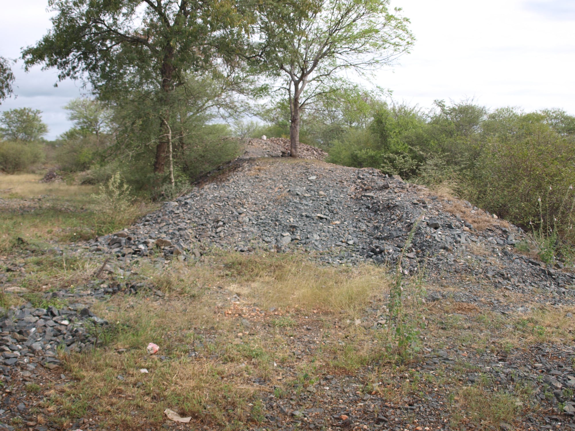
A waste rock stack from the New Zealand mine - the deepest on the Tati Goldfield at about 360 feet
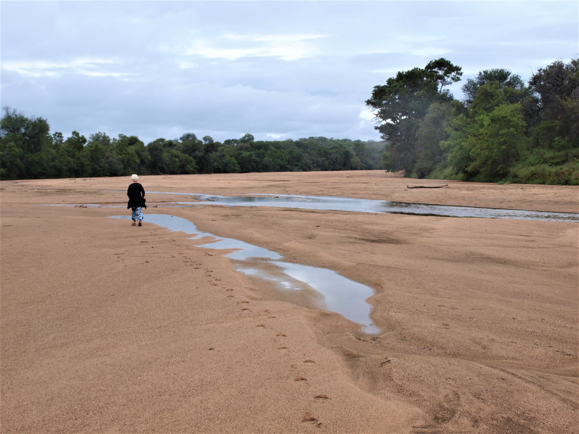
Old Tati Drift - probably little changed since Henry Stabb was here

Not all of the wildlife in Botswana lives in National Parks and you never know what you will find along the roadside
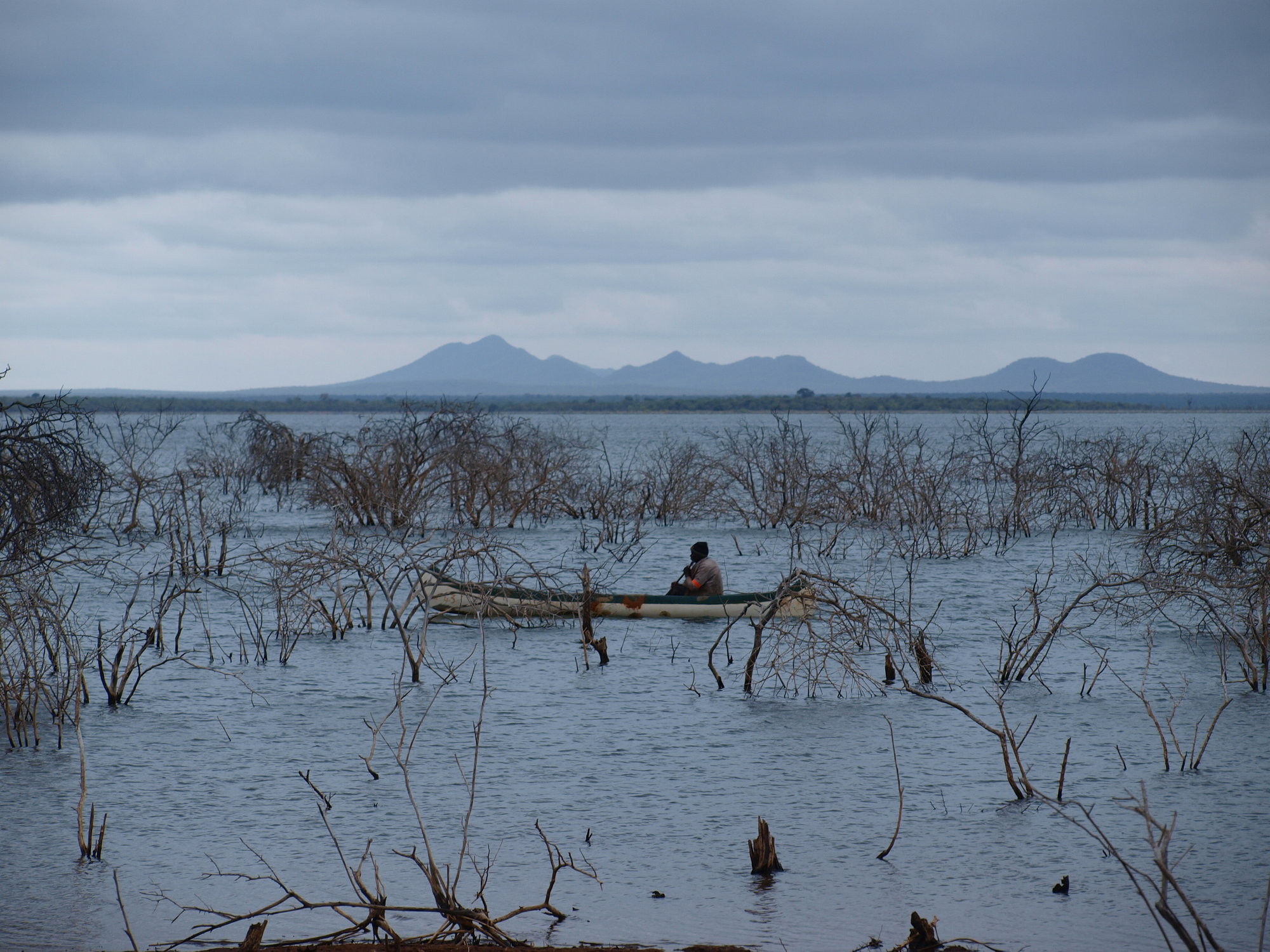
The waters of the Dikgatlhong Dam.
Old Tati was not just a mining village � it was also a road junction. One wagon road continued to Gubuluwayo, and the other stayed within the borders of modern day Botswana. Either could be used to reach the Victoria Falls. But before using either road Henry Stabb had to seek the permission of the Matabele King, Lobengula.
Old Tati was the scene of the first gold rush in Southern Africa in 1868. The rush attracted miners and hopefuls from South Africa, Denmark, Britain, Australia and New Zealand. Most were hoping for easily won alluvial gold, but in fact nearly all of the gold was in steeply dipping quartz reefs. What was needed to win the gold was skill and capital rather than raw enthusiasm, and most of the miners didn�t stay long. By the time Henry Stabb reached Old Tati the field was almost deserted. The affairs of the last mining company to work the field in the 1870�s were being wound up by Hugh Dobbie, an Australian miner, who gave the Stabb party an underground tour of the Blue Jacket mine.
�.very old workings extending for a considerable distance underground were long known to have existed here and it was on the site of them that the London and Limpopo Company made their excavations�the old tunnels and passages appear to have been very low and contracted, though chambers were in some places excavated to a very considerable size. The recent workings have in many places obliterated the old, but they always seem to have followed them�, it is strange that no iron implements of any kind have ever been found here; large round stone hammers are frequently to be met with and everywhere are traces that fire was the agent used to crack the quartz in the reefs before it could be worked out with the stone hammers.
�The fields are not being worked now, they are indeed practically abandoned, as the London and Limpopo Company has been wound up and are in liquidation and even a new steam quartz-crushing machine is standing without protection of any kind, exposed to all weathers and going rapidly with what other plant remains here, to ruin, no one being left to guard or look after it.
Old Tati lies completely deserted now, and largely reclaimed by the bush. but it is a fascinating site to poke around. Mining relics and waste heaps are everywhere.. The scars of the old drift across the Tati River that would have been used by Henry�s wagon are still plainly visible. And in 1875 Old Tati offered something that modern self drive tourists struggle to find in many parts of today�s Botswana � real coffee.
Mrs van Rooyen entertained us and gave us the usual Boer welcome of a cup of coffee on arrival. The coffee appeared very good, but Heavens above had we only known of what it had been made!! Mrs Francis would take none and she afterwards told us why and explained that she had not had the opportunity of warning any beforehand, but on arrival she had observed our hostess wash the very dirty faces of two extremely dirty little urchins with still dirtier noses in a wash basin, the contents of which she assured us were afterwards transferred to the kettle, boiled and manufactured into the coffee we had enjoyed so much�Still, what the eye did not see, the heart did not feel.
The drive from Shoshong to Old Tati today takes about 3 1/2 hours with the last half hour being on a gravel road. The route takes you past villages with a rich history like Palapye, skirts the western end of the picturesque Tswapong Hills, and carries on up the A1 highway to the modern village of Tonota. The route then swings east toward the border with Zimbabwe. The wildlife in Botswana is not all in national parks, and we were pleased we had our camera ready at hand !
The road ends at the Tati River drift and you have to cross the sandy river bed on foot and walk the last 2 km to reach the site of the old mining village. It is hard to imagine now, but Old Tati once had a population of about 500. It could boast a post office, several stores, a Jesuit mission and a small school with about 13 pupils. And it has one very unusual claim to fame � the first performance of a Shakespearean play in Bechuanaland was held here in 1869. The play was Hamlet. What the local population made of this is not recorded. There is no interpretive signage, but we were able to identify a few of the ruined buildings and structures from contemporary paintings and descriptions.
There is also a tiny cemetery. This has a special significance for us personally � the cemetery holds 8 graves, and one holds a New Zealand miner, killed in an explosion in 1870. The very first New Zealander to be buried in Botswana.
Something that Henry Stabb couldn't do was to visit the waters of the Dikgatlhong Dam, 10 km downstream. It was built in 2012, and is Botswana's largest water supply reservoir. Had it been there in 1875 I'm sure he would have made the detour.
A waste rock stack from the New Zealand mine - the deepest on the Tati Goldfield at about 360 feet
Old Tati Drift - probably little changed since Henry Stabb was here
Not all of the wildlife in Botswana lives in National Parks and you never know what you will find along the roadside
The waters of the Dikgatlhong Dam.
Old Tati was not just a mining village � it was also a road junction. One wagon road continued to Gubuluwayo, and the other stayed within the borders of modern day Botswana. Either could be used to reach the Victoria Falls. But before using either road Henry Stabb had to seek the permission of the Matabele King, Lobengula.


